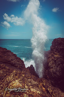
dikwella hummanaya,dikwella blowhole,dickwella tourism,places to see in dickwellaHummanaya Dickwella - Blowhole is the only known blowhole in Sri Lanka
This is default featured slide 1 title
Go to Blogger edit html and find these sentences.Now replace these sentences with your own descriptions.
This is default featured slide 2 title
Go to Blogger edit html and find these sentences.Now replace these sentences with your own descriptions.
This is default featured slide 3 title
Go to Blogger edit html and find these sentences.Now replace these sentences with your own descriptions.
This is default featured slide 4 title
Go to Blogger edit html and find these sentences.Now replace these sentences with your own descriptions.
This is default featured slide 5 title
Go to Blogger edit html and find these sentences.Now replace these sentences with your own descriptions.
Showing posts with label Village Beauty Of SriLanka. Show all posts
Friday, June 1, 2018
Hummanaya Dickwella - Blowhole is the only known blowhole in Sri Lanka
Hummanaya Blowhole is the only known blowhole in Sri Lanka and it is
considered to be the second largest blowhole in the world. It's situated
in Dikwella in Matara district.
dikwella hummanaya,dikwella blowhole,dickwella tourism,places to see in dickwellaHummanaya Dickwella - Blowhole is the only known blowhole in Sri Lanka
Friday, May 11, 2018
Sinharaja Forest Reserve in SriLanka
Sinharaja Forest Reserve is a national park and a biodiversity hotspot in Sri Lanka. It is of international significance and has been designated a Biosphere Reserve and World Heritage Site by UNESCO.
The hilly virgin rainforest, part of the Sri Lanka lowland rain forests ecoregion, was saved from the worst of commercial logging by its inaccessibility, and was designated a World Biosphere Reserve in 1978 and a World Heritage Site in 1988. The reserve's name translates as Lion Kingdom.
The reserve is only 21 km (13 mi) from east to west, and a maximum of 7 km (4.3 mi) from north to south, but it is a treasure trove of endemic species, including trees, insects, amphibians, reptiles, birds, and mammals.
Because of the dense vegetation, wildlife is not as easily seen as at dry-zone national parks such as Yala. There are about 3 elephants, and 15 or so[vague] leopards. The most common larger mammal is the endemic purple-faced langur.
Birds tend to move in mixed feeding flocks, invariably led by the fearless SriLanka Crested Drongo and the noisy orange-billed babbler. Of Sri Lanka's 26 endemic birds, the 20 rainforest species all occur here, including the elusive red-faced malkoha, green-billed coucal and Sri Lanka blue magpie.
Reptiles include the endemic green pit viper and hump-nosed vipers, and there are a large variety of amphibians, especially tree frogs. Invertebrates include the endemic common birdwing, butterfly and leeches.
The hilly virgin rainforest, part of the Sri Lanka lowland rain forests ecoregion, was saved from the worst of commercial logging by its inaccessibility, and was designated a World Biosphere Reserve in 1978 and a World Heritage Site in 1988. The reserve's name translates as Lion Kingdom.
The reserve is only 21 km (13 mi) from east to west, and a maximum of 7 km (4.3 mi) from north to south, but it is a treasure trove of endemic species, including trees, insects, amphibians, reptiles, birds, and mammals.
Because of the dense vegetation, wildlife is not as easily seen as at dry-zone national parks such as Yala. There are about 3 elephants, and 15 or so[vague] leopards. The most common larger mammal is the endemic purple-faced langur.
Birds tend to move in mixed feeding flocks, invariably led by the fearless SriLanka Crested Drongo and the noisy orange-billed babbler. Of Sri Lanka's 26 endemic birds, the 20 rainforest species all occur here, including the elusive red-faced malkoha, green-billed coucal and Sri Lanka blue magpie.
Reptiles include the endemic green pit viper and hump-nosed vipers, and there are a large variety of amphibians, especially tree frogs. Invertebrates include the endemic common birdwing, butterfly and leeches.
Social Integration
The reserve is well-integrated with the local population that are living in some dozens of villages dotted along the border. The villages are more in number along the southern border whilst the presence of some large estates along the northern border has resulted in only a few villages there. The locals collect herbal medicine, edible fruits, nuts, mushrooms, other non-timber forest products including bees honey and a sugary sap collected from a local palm species of the genus Caryota. The sap is converted into jaggery, a local brew and vinegar. Local people walk in the forest to collect above items when they are not busy with their other agricultural pursuits. In addition, the crystal-clear water coming from dozens of streams is the main water source for all people living around the reserve. For generations, local people trekked through the forest from south to north to make their annual pilgrimage to the Adams Peak.Adam’s Peak - Best Places To Visit When Travel To SriLanka #2
Adam's Peak (Sinhalese: Sri Pada or "Sri Paadaya" (ශ්රී පාදය) and Samanalakanda, සමනළ කන්ද; Lit. "Butterfly Mountain"; Tamil: சிவனொளி பாதமலை, Sivanolipatha Malai; Arabic: Al-Rohun) is a 2,243 m (7,359 ft) tall conical mountain located in central Sri Lanka. It is well known for the Sri Pada, i.e., "sacred footprint", a 1.8 m (5 ft 11 in) rock formation near the summit, which in Buddhist tradition is held to be the footprint of the Buddha, in Hindu tradition that of Shiva and in Islamic and Christian tradition that of Adam, or that of St. Thomas.
The mountain is located in the southern reaches of the Central Highlands in the Ratnapura District and Nuwara Eliya district of the Sabaragamuwa Province and Central Province —lying about 40 km northeast of the city of Ratnapura and 32 km southwest of the city of Hatton. The surrounding region is largely forested hills, with no mountain of comparable size nearby. The region along the mountain is a wildlife reserve, housing many species varying from elephants to leopards, and including many endemic species.
Adam's Peak is important as a watershed. The districts to the south and the east of Adam's Peak yield precious stones—emeralds, rubies and sapphires, for which the island has been famous, and which earned for its ancient name of Ratnadvipa.[3]
Access to the mountain is possible by 6 trails:
Ratnapura-Palabaddala, Hatton-Nallathanni, Kuruwita-Erathna,
Murraywatte, Mookuwatte and Malimboda. The Nallathanni & Palabaddala
routes are most favored by those undertaking the climb, while the
Kuruwita-Erathna trail is used less often; these trails are linked to
major cities or town by bus, accounting for their popular use. The
Murraywatte, Mookuwatte and Malimboda routes are hardly used, but do
intersect with the Palabaddala road midway through the ascent. The usual
route taken by most pilgrims is ascent via Hatton and descent via
Ratnapura; although the Hatton trail is the steepest, it is also shorter
than any of the other trails by approximately five kilometers.
Once one of the starting 'nodes' of Palabadalla, Nallathanni or Erathna are reached, the rest of the ascent is done on foot through the forested mountainside on the steps built into it. The greater part of the track leading from the base to the summit consists of thousands of steps built in cement or rough stones. The trails are illuminated with electric light, making night-time ascent possible and safe to do even when accompanied by children. Rest stops and wayside shops along the trails serve refreshments and supplies.
Whilst there are many ancient monuments on the mountain, there is an important Peace Pagoda located halfway up, built by Nipponzan Myohoji in 1978.
Due to its significance to the various people that inhabit the country, the mountain is referred to by a variety of names.
The often used Sri Pada is derived from Sanskrit, used by the Sinhalese people in a religious context; this name also has meaning in Pāli, and may be translated roughly as "the sacred foot". It refers to the footprint-shaped mark at the summit, which is believed by Buddhists to be that of the Buddha. Christian and Islamic traditions assert that it is the footprint of Adam, left when first setting foot on Earth after having been cast out of paradise, giving it the name "Adam's Peak".[citation needed] Hindu tradition refers to the footprint as that of the Hindu deity Shiva, and thus names the mountain Shiva padam (Shiva's foot) in Tamil. Tamils may also use the name Shivanolipatha Malai to refer to the mountain.
Another Sinhala name for the mountain is Samanalakanda, which refers either to the deity Saman, who is said to live upon the mountain, or to the butterflies (samanalayā) that frequent the mountain during their annual migrations to the region. The name Sri Paada, however, is the more commonly used.
Other local and historic names include Ratnagiri ("jewelled hill"), Samantakuta ("Peak of Saman"), Svargarohanam ("the climb to heaven"), Mount Rohana and other variations on the root Rohana.
The Italian merchant Marco Polo in his Travels of 1298 CE noted that Adam's Peak was an important place of pilgrimage but did not mention a footprint in the rock.[4] The Arab traveler Ibn Battuta climbed to the summit of the mountain which he called Sarandīb in 1344 CE. In his description he mentions a stairway and iron stanchions with chains to help the pilgrims.[5][6][7] John Davy brother of the noted chemist Sir Humphry Davy visited the peak in 1817. He recorded observing an oversized foot print carved in stone and ornamented with a single margin of brass and studded with gems.[8]
It is revered as a holy site by Buddhists, Hindus, some Muslims and Christians.
It has specific qualities that cause it to stand out and be noticed;
including its dominant and outstanding profile, and the boulder at the
peak that contains an indentation resembling a footprint. As the 1910, Encyclopædia Britannica notes[9]
The mountain is most often scaled from December to May. During other months it is hard to climb the mountain due to very heavy rain, extreme wind, and thick mist.The peak pilgrimage season is in April, and the goal is to be on top of the mountain at sunrise, when the distinctive shape of the mountain casts a triangular shadow on the surrounding plain and can be seen to move quickly downward as the sun rises.
For Buddhists, the footprint mark is the left foot of the Buddha,
left behind when Buddha visited Sri Lanka, as a symbol for worship at
the invitation of Buddhist God Saman.
Tamil Hindus consider it as the footprint of Lord Shiva. It is also fabled that the mountain is the legendary mount Trikuta the capital of Ravana during the Ramayana times from where he ruled Lanka.
Some Muslims and Christians in Sri Lanka ascribe it to where Adam, the first Ancestor, set foot as he was exiled from the Garden of Eden[citation needed]. The legends of Adam are connected to the idea that Sri Lanka was the original Eden,[10][11] and in the Muslim tradition that Adam was 30 ft tall.[12][citation needed]
A shrine to Saman, a Buddhist "deity" (People who have spent spiritual life during their life on earth and done pacificism service to regions are deified by Sri Lankan Buddhists) charged with protecting the mountain top, can be found near the footprint.
The mountain is located in the southern reaches of the Central Highlands in the Ratnapura District and Nuwara Eliya district of the Sabaragamuwa Province and Central Province —lying about 40 km northeast of the city of Ratnapura and 32 km southwest of the city of Hatton. The surrounding region is largely forested hills, with no mountain of comparable size nearby. The region along the mountain is a wildlife reserve, housing many species varying from elephants to leopards, and including many endemic species.
Adam's Peak is important as a watershed. The districts to the south and the east of Adam's Peak yield precious stones—emeralds, rubies and sapphires, for which the island has been famous, and which earned for its ancient name of Ratnadvipa.[3]
Trails
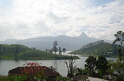
The Holy peak viewed at Adiyamalatenna Ambalama - Kuruwita-Erathna trail
Once one of the starting 'nodes' of Palabadalla, Nallathanni or Erathna are reached, the rest of the ascent is done on foot through the forested mountainside on the steps built into it. The greater part of the track leading from the base to the summit consists of thousands of steps built in cement or rough stones. The trails are illuminated with electric light, making night-time ascent possible and safe to do even when accompanied by children. Rest stops and wayside shops along the trails serve refreshments and supplies.
Whilst there are many ancient monuments on the mountain, there is an important Peace Pagoda located halfway up, built by Nipponzan Myohoji in 1978.
Nomenclature
Mahagiri Dambaya
The often used Sri Pada is derived from Sanskrit, used by the Sinhalese people in a religious context; this name also has meaning in Pāli, and may be translated roughly as "the sacred foot". It refers to the footprint-shaped mark at the summit, which is believed by Buddhists to be that of the Buddha. Christian and Islamic traditions assert that it is the footprint of Adam, left when first setting foot on Earth after having been cast out of paradise, giving it the name "Adam's Peak".[citation needed] Hindu tradition refers to the footprint as that of the Hindu deity Shiva, and thus names the mountain Shiva padam (Shiva's foot) in Tamil. Tamils may also use the name Shivanolipatha Malai to refer to the mountain.
Another Sinhala name for the mountain is Samanalakanda, which refers either to the deity Saman, who is said to live upon the mountain, or to the butterflies (samanalayā) that frequent the mountain during their annual migrations to the region. The name Sri Paada, however, is the more commonly used.
Other local and historic names include Ratnagiri ("jewelled hill"), Samantakuta ("Peak of Saman"), Svargarohanam ("the climb to heaven"), Mount Rohana and other variations on the root Rohana.
History
Sri Pada is first mentioned (as `Samanthakuta') in the Deepawamsa,[citation needed] the earliest Pali chronicle, (4th century), and also in the 5th century chronicle Mahawamsa, where it is stated that the Buddha visited the mountain peak. The chronicle Rajavaliya states that the King Valagamba (1st century BCE) had taken refuge in the forests of Adam's Peak against invaders from India, and later returned to Anuradhapura. The Mahawamsa again mentions the visit of King Vijayabahu I (1058–1114) to the mountain. The famous Chinese pilgrim and Buddhist traveler Fa Hien stayed in Sri Lanka in 411–12 CE and mentions Sri Pada although it is not made clear whether he actually visited it.The Italian merchant Marco Polo in his Travels of 1298 CE noted that Adam's Peak was an important place of pilgrimage but did not mention a footprint in the rock.[4] The Arab traveler Ibn Battuta climbed to the summit of the mountain which he called Sarandīb in 1344 CE. In his description he mentions a stairway and iron stanchions with chains to help the pilgrims.[5][6][7] John Davy brother of the noted chemist Sir Humphry Davy visited the peak in 1817. He recorded observing an oversized foot print carved in stone and ornamented with a single margin of brass and studded with gems.[8]
The Sacred Mountain
The village of Nallathanniya at the feet of the mountain, where the stairs begin
"For a long period Sri Pada was supposed to be the highest mountain in Ceylon, but actual survey makes it only 7353 ft. above sea-level. This elevation is chiefly remarkable as the resort of pilgrims from all parts of the East. The hollow in the lofty rock that crowns the summit is said by the Buddhists of Buddha, by the Hindus to be the footstep of Siva, by some Muslims of Adam, whilst the Portuguese Christians were divided between the conflicting claims of St Thomas and the eunuch of Candace, queen of Ethiopia. The footstep is covered by a handsome roof, and is guarded by the priests of a rich monastery half-way up the mountain, who maintain a shrine on the summit of the peak."It is an important pilgrimage site, especially for Buddhists. Pilgrims walk up the mountain, following a variety of difficult routes up thousands of steps. The journey takes several hours at least.
The mountain is most often scaled from December to May. During other months it is hard to climb the mountain due to very heavy rain, extreme wind, and thick mist.The peak pilgrimage season is in April, and the goal is to be on top of the mountain at sunrise, when the distinctive shape of the mountain casts a triangular shadow on the surrounding plain and can be seen to move quickly downward as the sun rises.
Legends
A view of Adam's peak from Maskeliya town
Tamil Hindus consider it as the footprint of Lord Shiva. It is also fabled that the mountain is the legendary mount Trikuta the capital of Ravana during the Ramayana times from where he ruled Lanka.
Some Muslims and Christians in Sri Lanka ascribe it to where Adam, the first Ancestor, set foot as he was exiled from the Garden of Eden[citation needed]. The legends of Adam are connected to the idea that Sri Lanka was the original Eden,[10][11] and in the Muslim tradition that Adam was 30 ft tall.[12][citation needed]
A shrine to Saman, a Buddhist "deity" (People who have spent spiritual life during their life on earth and done pacificism service to regions are deified by Sri Lankan Buddhists) charged with protecting the mountain top, can be found near the footprint.
Sigiriya - Lion’s Rock - Best Places To Visit When Travel To SriLanka #1
Sigiriya or Sinhagiri (Lion Rock Sinhalese: සීගිරිය, Tamil: சிகிரியா, pronounced see-gi-ri-yə) is an ancient rock fortress located in the northern Matale District near the town of Dambulla in the Central Province, Sri Lanka.
The name refers to a site of historical and archaeological significance
that is dominated by a massive column of rock nearly 200 metres
(660 ft) high. According to the ancient Sri Lankan chronicle the Culavamsa, this site was selected by King Kasyapa
(477 – 495 CE) for his new capital. He built his palace on the top of
this rock and decorated its sides with colourful frescoes. On a small
plateau about halfway up the side of this rock he built a gateway in the
form of an enormous lion. The name of this place is derived from this
structure —Sīhāgiri, the Lion Rock. The capital and the royal palace was
abandoned after the king's death. It was used as a Buddhist monastery
until the 14th century.[1]
Sigiriya today is a UNESCO listed World Heritage Site. It is one of the best preserved examples of ancient urban planning.[2]
According to the Palm Leaf Book (Puskola Potha) of Ravana Watha (About Ravana) the architect of the Sigiriya was a person called Maya Danava. He built up Sigiriya on the instructions given by King Visthavasa (Vesamuni) the father of Ravana. During that period the Sigiriya was called Alakamandava and during the period of King Kuwera it was called Cithranakuta. After the death of Ravana, Vibeeshana became the king and he shifted the kingdom to Kelaniya. As per this book, Chiththaraja had used Alakamandava as his residence. Chiththaraja was a relation of Vibeeshana and a Patrician of Yakka. It was also stated that Chiththaraja was one of a persons who helped Prince Pandukabhaya to get the kingship. Parents of Pandukabhaya were descended from the tribe of Chiththaraja.
In addition, Ravana Watha was also described that Prince Kassapa who was the son of King Daathusena has selected the Chithrakuta as his residence due to the fact that her mother was a follower of Yakka belief and also she descended from them. King Kassapa was the only king who did reconstruction and maintained the Chiththakuta as done by the king Ravana. The famous wall paintings in the Chiththakuta ( Later Sigiriya ) can be treated as displaying about the Sinhala Land i.e. Sri Lanka. The Ravana Watha explains that the picture of blue coloured lady represents the Yakka Tribe and other ladies represent the Tribes of Naga (Cobra), Deva (Divine) and Gandabhbha (Odors) and the beautiful flowers show the unity of the country.[3]
Buddhist monastic settlements were established during the 3rd century BCE in the western and northern slopes of the boulder-strewn hills surrounding the Sigiriya rock. Several rock shelters or caves were created during this period. These shelters were made under large boulders, with carved drip ledges around the cave mouths. Rock inscriptions are carved near the drip ledges on many of the shelters, recording the donation of the shelters to the Buddhist monastic order as residences. These were made in the period between the 3rd century BCE and the 1st century CE.
In 477 CE, Kashyapa, the king’s son by a non-royal consort, seized the throne from King Dhatusena, following a coup assisted by Migara, the King’s nephew and army commander. The rightful heir, Moggallana, fearing for his life, fled to South India. Afraid of an attack by Moggallana, Kashyapa moved the capital and his residence from the traditional capital of Anuradhapura to the more secure Sigiriya. During King Kashyapa’s reign (477 to 495 CE), Sigiriya was developed into a complex city and fortress.[1][2] Most of the elaborate constructions on the rock summit and around it, including defensive structures, palaces, and gardens, date from this period.
The Culavamsa describes King Kashyapa as the son of King Dhatusena. Kashyapa murdered his father by walling him up alive and then usurping the throne which rightfully belonged to his half-brother Moggallana, Dhatusena's son by the true queen. Moggallana fled to India to escape being assassinated by Kashyapa, but vowed revenge. In India he raised an army with the intention of returning and retaking the throne of Sri Lanka, which he considered to be rightfully his. Expecting the inevitable return of Moggallana, Kashyapa is said to have built his palace on the summit of Sigiriya as a fortress as well as a pleasure palace. Moggallana finally arrived, declared war, and defeated Kashyapa in 495 CE. During the battle Kashyapa's armies abandoned him and he committed suicide by falling on his sword.
The Culavamsa and folklore inform us that the battle-elephant on which Kashyapa was mounted changed course to take a strategic advantage, but the army misinterpreted the movement as the king's having opted to retreat, prompting the army to abandon him altogether. It is said that being too proud to surrender he took his dagger from his waistband, cut his throat, raised the dagger proudly, sheathed it, and fell dead. Moggallana returned the capital to Anuradhapura, converting Sigiriya into a Buddhist monastery complex,[4] which survived until the 13th or 14th century. After this period, no records are found on Sigiriya until the 16th and 17th centuries, when it was used briefly as an outpost of the Kingdom of Kandy.
Alternative stories have the primary builder of Sigiriya as King Dhatusena, with Kashyapa finishing the work in honour of his father. Still other stories describe Kashyapa as a playboy king, with Sigiriya his pleasure palace. Even Kashyapa's eventual fate is uncertain. In some versions he is assassinated by poison administered by a concubine; in others he cuts his own throat when deserted in his final battle.[5] Still further interpretations regard the site as the work of a Buddhist community, without a military function. This site may have been important in the competition between the Mahayana and Theravada Buddhist traditions in ancient Sri Lanka.
In 1831 Major Jonathan Forbes of the 78th Highlanders of the British
army, while returning on horseback from a trip to Pollonnuruwa,
encountered the "bush covered summit of Sigiriya".[6]
Sigiriya came to the attention of antiquarians and, later,
archaeologists. Archaeological work at Sigiriya began on a small scale
in the 1890s. H.C.P. Bell was the first archaeologist to conduct
extensive research on Sigiriya. The Cultural Triangle Project, launched
by the Government of Sri Lanka,
focused its attention on Sigiriya in 1982. Archaeological work began on
the entire city for the first time under this project. There was a
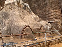
sculpted lion's head above the legs and paws flanking the entrance, but
the head collapsed years ago.
Sigiriya consists of an ancient citadel built by King Kashyapa during the 5th century. The Sigiriya site contains the ruins of an upper palace located on the flat top of the rock, a mid-level terrace that includes the Lion Gate and the mirror wall with its frescoes, the lower palaces located behind the lavish lower gardens, and moats and ramparts which protected the citadel. The site was both a palace and a fortress. The upper palace on the top of the rock includes cisterns cut into the rock.
John Still
in 1907 suggested, "The whole face of the hill appears to have been a
gigantic picture gallery... the largest picture in the world perhaps".[9]
The paintings would have covered most of the western face of the rock,
an area 140 metres long and 40 metres high. There are references in the
graffiti to 500 ladies in these paintings. However, most have been lost
forever. More frescoes, different from those on the rock face, can be
seen elsewhere, for example on the ceiling of the location called the
"Cobra Hood Cave".
Although the frescoes are classified as in the Anuradhapura period, the painting style is considered unique;[10] the line and style of application of the paintings differing from Anuradhapura paintings. The lines are painted in a form which enhances the sense of volume of the figures. The paint has been applied in sweeping strokes, using more pressure on one side, giving the effect of a deeper colour tone towards the edge. Other paintings of the Anuradhapura period contain similar approaches to painting, but do not have the sketchy lines of the Sigiriya style, having a distinct artists' boundary line. The true identity of the ladies in these paintings still have not been confirmed. There are various ideas about their identity. Some believe that they are the ladies of the king's while others think that they are women taking part in religious observances. These pictures have a close resemblance to paintings seen in the Ajanta caves in India.
Originally this wall was so highly polished that the king could see
himself whilst he walked alongside it. Made of brick masonry and covered
in highly polished white plaster,[11]
the wall is now partially covered with verses scribbled by visitors,
some of them dating from as early as the 8th century. People of all
types wrote on the wall, on varying subjects such as love, irony, and
experiences of all sorts. Further writing on the mirror wall now has
been banned for the protection of the old writings.
The Archaeological Commissioner of Ceylon, Senarath Paranavithana, deciphered 685 verses written in the 8th, 9th and 10th centuries CE on the mirror wall.[12] One such poem from these long-past centuries, roughly translated from Sinhala, is:[13]
The water gardens can be seen in the central section of the western
precinct. Three principal gardens are found here. The first garden
consists of a plot surrounded by water. It is connected to the main
precinct using four causeways, with gateways placed at the head of each
causeway. This garden is built according to an ancient garden form known
as char bagh, and is one of the oldest surviving models of this form.
The second contains two long, deep pools set on either side of the path. Two shallow, serpentine streams lead to these pools. Fountains made of circular limestone plates are placed here. Underground water conduits supply water to these fountains which are still functional, especially during the rainy season. Two large islands are located on either side of the second water garden. Summer palaces are built on the flattened surfaces of these islands. Two more islands are located farther to the north and the south. These islands are built in a manner similar to the island in the first water garden.
The third garden is situated on a higher level than the other two. It
contains a large, octagonal pool with a raised podium on its northeast
corner. The large brick and stone wall of the citadel is on the eastern
edge of this garden.
The water gardens are built symmetrically on an east-west axis. They are connected with the outer moat on the west and the large artificial lake to the south of the Sigiriya rock. All the pools are also interlinked using an underground conduit network fed by the lake, and connected to the moats. A miniature water garden is located to the west of the first water garden, consisting of several small pools and watercourses. This recently discovered smaller garden appears to have been built after the Kashyapan period, possibly between the 10th and 13th centuries.
Sigiriya today is a UNESCO listed World Heritage Site. It is one of the best preserved examples of ancient urban planning.[2]
The History
Legendary Past
Lal Sirinivas and Mirando Obesekara described Sigiriya as a post historical archeology turning point of Ravana. According to them, Sigiriya may be the Alakamandava (the City of the Gods) that was built up before 50 centuries ago by King Kubera who was the half-brother of Ravana (Ravan) as described in the Ramayanaya.According to the Palm Leaf Book (Puskola Potha) of Ravana Watha (About Ravana) the architect of the Sigiriya was a person called Maya Danava. He built up Sigiriya on the instructions given by King Visthavasa (Vesamuni) the father of Ravana. During that period the Sigiriya was called Alakamandava and during the period of King Kuwera it was called Cithranakuta. After the death of Ravana, Vibeeshana became the king and he shifted the kingdom to Kelaniya. As per this book, Chiththaraja had used Alakamandava as his residence. Chiththaraja was a relation of Vibeeshana and a Patrician of Yakka. It was also stated that Chiththaraja was one of a persons who helped Prince Pandukabhaya to get the kingship. Parents of Pandukabhaya were descended from the tribe of Chiththaraja.
In addition, Ravana Watha was also described that Prince Kassapa who was the son of King Daathusena has selected the Chithrakuta as his residence due to the fact that her mother was a follower of Yakka belief and also she descended from them. King Kassapa was the only king who did reconstruction and maintained the Chiththakuta as done by the king Ravana. The famous wall paintings in the Chiththakuta ( Later Sigiriya ) can be treated as displaying about the Sinhala Land i.e. Sri Lanka. The Ravana Watha explains that the picture of blue coloured lady represents the Yakka Tribe and other ladies represent the Tribes of Naga (Cobra), Deva (Divine) and Gandabhbha (Odors) and the beautiful flowers show the unity of the country.[3]
Historical Past
The environment around the Sigiriya may have been inhabited since prehistoric times. There is clear evidence that the many rock shelters and caves in the vicinity were occupied by Buddhist monks and ascetics from as early as the 3rd century BCE. The earliest evidence of human habitation at Sigiriya is the Aligala rock shelter to the east of Sigiriya rock, indicating that the area was occupied nearly five thousand years ago during the Mesolithic Period.Buddhist monastic settlements were established during the 3rd century BCE in the western and northern slopes of the boulder-strewn hills surrounding the Sigiriya rock. Several rock shelters or caves were created during this period. These shelters were made under large boulders, with carved drip ledges around the cave mouths. Rock inscriptions are carved near the drip ledges on many of the shelters, recording the donation of the shelters to the Buddhist monastic order as residences. These were made in the period between the 3rd century BCE and the 1st century CE.
In 477 CE, Kashyapa, the king’s son by a non-royal consort, seized the throne from King Dhatusena, following a coup assisted by Migara, the King’s nephew and army commander. The rightful heir, Moggallana, fearing for his life, fled to South India. Afraid of an attack by Moggallana, Kashyapa moved the capital and his residence from the traditional capital of Anuradhapura to the more secure Sigiriya. During King Kashyapa’s reign (477 to 495 CE), Sigiriya was developed into a complex city and fortress.[1][2] Most of the elaborate constructions on the rock summit and around it, including defensive structures, palaces, and gardens, date from this period.
The Culavamsa describes King Kashyapa as the son of King Dhatusena. Kashyapa murdered his father by walling him up alive and then usurping the throne which rightfully belonged to his half-brother Moggallana, Dhatusena's son by the true queen. Moggallana fled to India to escape being assassinated by Kashyapa, but vowed revenge. In India he raised an army with the intention of returning and retaking the throne of Sri Lanka, which he considered to be rightfully his. Expecting the inevitable return of Moggallana, Kashyapa is said to have built his palace on the summit of Sigiriya as a fortress as well as a pleasure palace. Moggallana finally arrived, declared war, and defeated Kashyapa in 495 CE. During the battle Kashyapa's armies abandoned him and he committed suicide by falling on his sword.
The Culavamsa and folklore inform us that the battle-elephant on which Kashyapa was mounted changed course to take a strategic advantage, but the army misinterpreted the movement as the king's having opted to retreat, prompting the army to abandon him altogether. It is said that being too proud to surrender he took his dagger from his waistband, cut his throat, raised the dagger proudly, sheathed it, and fell dead. Moggallana returned the capital to Anuradhapura, converting Sigiriya into a Buddhist monastery complex,[4] which survived until the 13th or 14th century. After this period, no records are found on Sigiriya until the 16th and 17th centuries, when it was used briefly as an outpost of the Kingdom of Kandy.
Alternative stories have the primary builder of Sigiriya as King Dhatusena, with Kashyapa finishing the work in honour of his father. Still other stories describe Kashyapa as a playboy king, with Sigiriya his pleasure palace. Even Kashyapa's eventual fate is uncertain. In some versions he is assassinated by poison administered by a concubine; in others he cuts his own throat when deserted in his final battle.[5] Still further interpretations regard the site as the work of a Buddhist community, without a military function. This site may have been important in the competition between the Mahayana and Theravada Buddhist traditions in ancient Sri Lanka.
Archaeological remains and features
The Lion Gate and Climbing Stretch
Sigiriya consists of an ancient citadel built by King Kashyapa during the 5th century. The Sigiriya site contains the ruins of an upper palace located on the flat top of the rock, a mid-level terrace that includes the Lion Gate and the mirror wall with its frescoes, the lower palaces located behind the lavish lower gardens, and moats and ramparts which protected the citadel. The site was both a palace and a fortress. The upper palace on the top of the rock includes cisterns cut into the rock.
Close up of the Lion's Paw
Site plan
Sigiriya is considered to be one of the most important urban planning sites of the first millennium, and the site plan is considered very elaborate and imaginative. The plan combined concepts of symmetry and asymmetry to intentionally interlock the man-made geometrical and natural forms of the surroundings. On the west side of the rock lies a park for the royals, laid out on a symmetrical plan; the park contains water-retaining structures, including sophisticated surface/subsurface hydraulic systems, some of which are working today. The south contains a man-made reservoir; these were extensively used from the previous capital of the dry zone of Sri Lanka. Five gates were placed at entrances. The more elaborate western gate is thought to have been reserved for the royals.[7][8]Frescoes
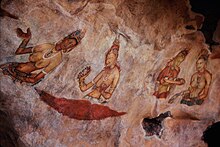
Artwork
Although the frescoes are classified as in the Anuradhapura period, the painting style is considered unique;[10] the line and style of application of the paintings differing from Anuradhapura paintings. The lines are painted in a form which enhances the sense of volume of the figures. The paint has been applied in sweeping strokes, using more pressure on one side, giving the effect of a deeper colour tone towards the edge. Other paintings of the Anuradhapura period contain similar approaches to painting, but do not have the sketchy lines of the Sigiriya style, having a distinct artists' boundary line. The true identity of the ladies in these paintings still have not been confirmed. There are various ideas about their identity. Some believe that they are the ladies of the king's while others think that they are women taking part in religious observances. These pictures have a close resemblance to paintings seen in the Ajanta caves in India.
Mirror wall
The mirror wall and spiral stairs leading to the frescoes
The Archaeological Commissioner of Ceylon, Senarath Paranavithana, deciphered 685 verses written in the 8th, 9th and 10th centuries CE on the mirror wall.[12] One such poem from these long-past centuries, roughly translated from Sinhala, is:[13]
"I am Budal [the writer's name]. Came with hundreds of people to see Sigiriya. Since all the others wrote poems, I did not!"
Gardens
The Gardens of the Sigiriya city are one of the most important aspects of the site, as it is among the oldest landscaped gardens in the world. The gardens are divided into three distinct but linked forms: water gardens, cave and boulder gardens, and terraced gardens.Water gardens
A pool in the garden complex
The second contains two long, deep pools set on either side of the path. Two shallow, serpentine streams lead to these pools. Fountains made of circular limestone plates are placed here. Underground water conduits supply water to these fountains which are still functional, especially during the rainy season. Two large islands are located on either side of the second water garden. Summer palaces are built on the flattened surfaces of these islands. Two more islands are located farther to the north and the south. These islands are built in a manner similar to the island in the first water garden.
The gardens of Sigiriya, as seen from the summit of the Sigiriya rock
The water gardens are built symmetrically on an east-west axis. They are connected with the outer moat on the west and the large artificial lake to the south of the Sigiriya rock. All the pools are also interlinked using an underground conduit network fed by the lake, and connected to the moats. A miniature water garden is located to the west of the first water garden, consisting of several small pools and watercourses. This recently discovered smaller garden appears to have been built after the Kashyapan period, possibly between the 10th and 13th centuries.